Projects
 Lessons
Ideas
Lessons
Ideas
View this Project
Download this Etoy
| Title | Description |
|---|---|
|
|
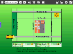
These two Etoys projects give students practice observing a familiar area, analyzing shapes and distances, and then representing them on a map grid of streets that are near their school building.This city map is then used in the second lesson as a place where a virtual school bus moves to locations on the map. |
|
|
These two Etoys projects give students practice observing a familiar area, analyzing shapes and distances, and then representing them on a map grid of streets that are near their school building.This city map is then used in the second lesson as a place where a virtual school bus moves to locations on the map. |